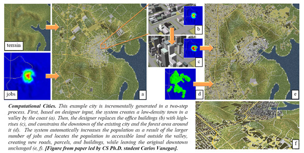
Computational Cities
09-10-2010
A new National Science Foundation award of $900K will fund a collaborative project between Purdue University and the University of California Berkeley to investigate a new computational and simulation framework for interactively modeling and visualizing socio-economic and geometric characteristics of urban areas. The framework is a synergistic collaboration of three different areas: computer graphics and visualization, behavioral urban modeling, and probabilistic graphical modeling. The Purdue team is led by Daniel Aliaga (Purdue PI, Computer Science) and Bedrich Benes (Purdue co-PI, Computer Graphics Technology). The Berkeley team is led by Paul Waddell (Berkeley PI, City & Regional Planning), and Michael Jordan (Berkeley co-PI, Electrical Engineering and Computer Science). The open-source research project will enable users – city planners, researchers, students, and citizens – to efficiently simulate urban processes not previously possible and to visualize the effects of adopting different urban policies and its effect on urban sustainability, equity, infrastructure, and economic development.
The team has elicited engagement from several agencies that will be impacted by our proposed methods: the Urban Land Institute, European Research Council, and Council for Scientific and Industrial Research. Furthermore, several organizations in the San Francisco Bay Area and Puget Sound region in Washington State will also serve as test-beds for the proposed research. Finally, our project will collaborate with other funded research projects, such as the NSF-funded Drought Research Initiative Network, on which PI Aliaga participates in order to investigate correlations between urban development and water/drought, and an Adobe research gift led by Benes and Aliaga. We also have opportunities to link this research to new research initiatives to model urban sustainability in urban areas in Asia, Europe, South Africa, and South America.